
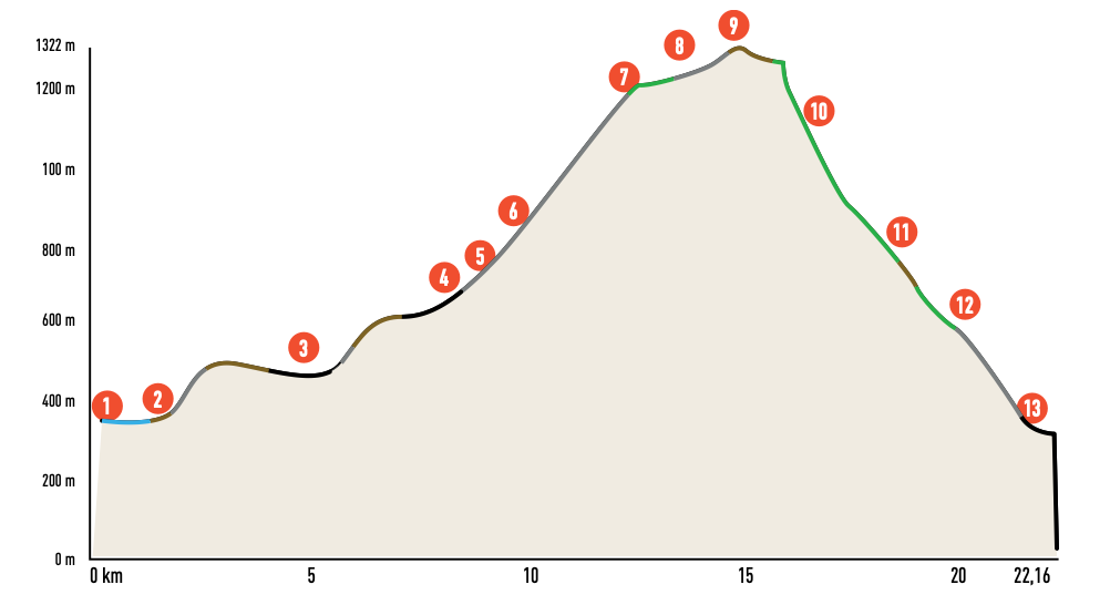
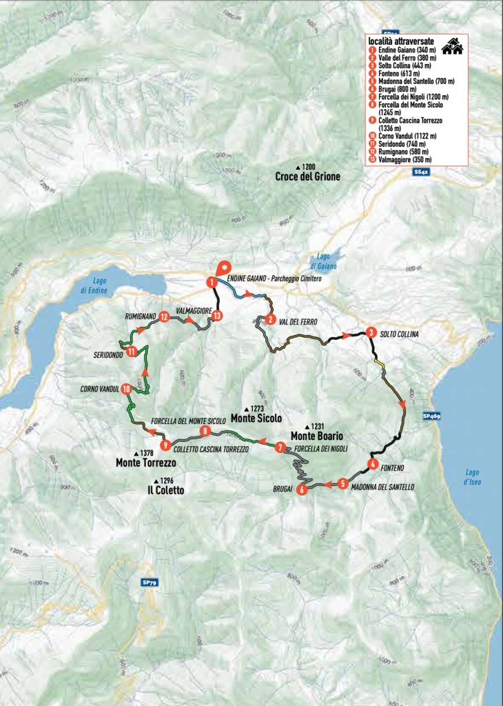
ENDINE – FONTENO – MOUNT TORREZZO
The Torrezzo & Vandul Trail is the twin route of the Sicolo Trail but has its unique features: it offers an independent and slightly easier descent, though it includes a short section where you must carry your bike down a steep staircase. Additionally, it provides an alternative ascent to Fonteno, avoiding the asphalt road entirely.
As with the Sicolo Trail, this loop tour is all about commitment: you are either climbing or descending, with few opportunities to rest. At times, when fatigue sets in and the gradient becomes too steep, pushing the bike by hand becomes necessary. The inclusion of the initial variant makes the ascent challenging from the very first pedal strokes, maintaining a demanding pace along the Mulattiera del Torès and the Sentiero dei Brugai, which consist of a mix of dirt, paved, and cemented paths.
Thankfully, between the two forks — Nigoli and Mount Sicolo — you can enjoy a magnificent single-track that is almost entirely rideable and offers breathtaking views of Lake Endine and Lake Sebino.
The traverse continues along dirt tracks and cemented sections, leading to the slopes of Mount Torrezzo. Near the farmstead of the same name, a long, spectacular trail begins, taking you directly back to the starting point while delivering excitement and satisfaction.
ITINERARY DESCRIPTION
From the Endine cemetery (1), walk along the perimeter wall to the left of the entrance and take the small road that follows the towpath of the Fossadone stream, which soon turns into a dirt road. After crossing a small (usually dry) valley, ascend alongside the stream, passing through a public green area featuring an exercise ground for Voluntary Civil Protection Dogs and a small lake. Continue along the towpath until you reach via G. Paglia. Turn left here and, shortly after, turn right onto via Campone. While you could take the standard road to Solto Collina and Fonteno, we suggest a more engaging alternative.
Cross via Paglia and take the dirt road running alongside the Fossadone stream on the right. Follow it until you come to some picturesque pools of crystal-clear water and a ford. Here, turn right and ascend along a cemented road that winds steeply through woods and meadows. The climb takes you above the Valle del Ferro (2) to a point where the road flattens and becomes unpaved again. Near a right hairpin bend, take the path to the left, which is level or slightly downhill, and ford the valley.
The route, mostly along dirt roads, crosses several small valleys and proceeds without significant inclines. At the end of this section, you will find yourself on a slightly bumpy downhill road with a stunning view of the small Gaiano lake, Val Borlezza, and, in the distance, the Bossico plateau with the elegant Presolana peak on the horizon.
Upon reaching a small paved road, follow it downhill until it joins the provincial road connecting Solto Collina (3) and Fonteno. Turn right and begin climbing again. After a few hundred meters, you will reach a shrine at the junction with via Sales. Shortly afterward, take the road branching off to the right, climbing steeply. Follow it and quickly turn left onto CAI path n° 567. Descend briefly along a path to a spring, cross the small valley, and continue along a scenic trench path that connects to a dirt road.
Stay on the dirt road (marked CAI 567). After a short uphill stretch with concrete-paved hairpin bends, a long diagonal trail begins, with mild ascents, encircling the Colle di Luen and leading to the center of the village of Fonteno (4). Here, you can enjoy a spectacular view of Lake Iseo and the surrounding valley. Cross the village and, from the piazza, ascend via Campello. At the small church of Divo Rocho, continue to the right.
The narrow asphalt road is just the beginning. Soon, you will encounter the Mulattiera del Torès, a fully paved road climbing up to the Madonna del Santello (5), where a stop is a must. The mule track continues beneath the church’s porch and then through less steep sections, perfect for catching your breath. At the first fork, turn right, following signs for the Sentiero dei Brugai (6). This dirt road, with its steepest sections cemented, snakes up Monte Boér with 15 hairpin bends through the forest.
At the top, you will find a shrine and a small water fountain. A bit further on, turn right to reach the ridge at Nigoli (7). Here begins the ridge path connecting Monte Boér, Monte Sicolo, and Monte Torrezzo. Turn left, following CAI trail 568. After a brief uphill push, the path alternates between rideable ascents and descents. Along the way, you’ll traverse scenic clearings—proceed with caution during hunting seasons. At La Fopa del Còl, you’ll encounter informational panels about the Bueno Fonteno – Nueva Vida karst system, a wonder for caving enthusiasts.
Continue to a dirt road at Casini, near the Mount Sicolo fork (8). Follow a moderately climbing road that leads to Monte Torrezzo. At the first fork, turn right and ascend to the saddle leading to Cascina Torrezzo (9). From here, breathtaking views open over the Orobie Alps, Adamello, the Brescian Pre-Alps, and Lakes Iseo and Endine.
Begin the descent along CAI trail 612. The dirt track follows the crest of the Corna dei Fondi. At a hairpin bend, take a path to the right. After a brief ascent, the path descends in winding turns toward a viewpoint above the Belzignolo ramparts. Below, Lake Endine stretches across the valley floor, with the Sparavera ridges in the foreground. From here, descend cautiously on foot along steps equipped with handrails.
Return to the saddle along a smooth path leading to Corno Vandul (10). Continue toward the Valle dei Cervi (Deer Valley), crossing clearings and passing huts such as Baita Seridondo (11). Finally, follow the CAI 620 variant trail toward Rumignano (12) and descend to Valmaggiore (13). Navigate through the alleys of the village to return to your starting point.
Credits: bibliography “MTB from Bergamo to the Endine and Iseo Lakes” Versante Sud Editions


