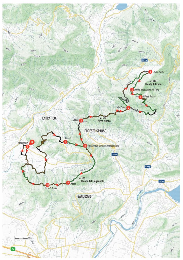
ZANDOBBIO – RIFUGIO GEMBA – ADRARA SAN MARTINO – SAN GIOVANNI DELLE FORMICHE
A wide-ranging, long, and rewarding loop itinerary that unfolds almost entirely on paths and dirt tracks. The expansive traverse from Zandobbio to the G.E.M.B.A. Refuge follows a scenic ridge, offering stunning views over both Val Cavallina and Valcalepio, with glimpses of Lake Iseo sparkling in the distance.
The first single track descent towards Adrara is an exhilarating reward for the effort of the preceding climb, providing an exciting test for your bike’s suspension and handling skills.
The return journey partially retraces the outward route up to the Colle di San Giovanni delle Formiche (San Giovanni delle Formiche Pass), before offering another delightful traverse between Gandosso and Zandobbio. Along technical trails and dirt roads, the route takes you through the Parco del Pitone, culminating in a short but intense technical descent back to Zandobbio. This final stretch immerses you in a captivating forest, providing the perfect conclusion to a memorable ride.
ITINERARY DESCRIPTION
From the center of Zandobbio (1), take the road on the left and follow it until the first turning on the right into via San Giorgio, continuing as far as the cemetery. Shortly afterward, on the right of the small church, take the dirt road of via Gabbione, which leads into the Plis del Malmera dei Montecchi and Colle degli Angeli. Follow the road, keeping left at both the first and second crossroads, and follow the signs for Cascina Gabbione (CAI signpost 651B). Pass through the gate and continue along the dirt road. At the end of the descent, take the detour to the right, marked by a CAI sign on a tree. Follow the dirt track, and at the top of a short climb, turn left where the track becomes a path.
After a few ups and downs, you will reach a hut. Leave it behind and descend to the left onto a dirt track, continuing downhill without detours. After crossing a small bridge over the Malmera River, continue straight. At the first fork, turn right onto the dirt track of via Fornaci, and follow it until it intersects with the road to Selva di Zandobbio. Follow this road for a short distance to the left, then turn right into via Alle Cave and immediately left onto the dirt road of via Carreccio, which leads to via Madonna della Neve. Continue until you reach via Sei; follow it to the end and then turn right onto via Grena.
Shortly afterward, you’ll see a yellow sign reading “Grena”, opposite the entrance to a large quarry. This marks the start of the first climb of the day. The ascent, consisting of nine pleasant hairpin bends on a gravel road, should be completed without detours until it intersects with via Corno, the asphalt road ascending from Entratico. Turn right and continue climbing.
At the Sommi summit (2), when the road begins to descend, take the small dirt road on the left, following the signs for San Giovanni alle Formiche (CAI 616). Shortly afterward, take the path to the left (CAI 616), which leads through a series of up-and-down sections to a wide dirt road near a farmstead surrounded by chestnut trees.
Continue left on the dirt track (signposted Berzo San Fermo – CAI 616). A pleasant descent will take you to the tarmac road of via Gafforelli, which you’ll follow to the locality Casino (3). Here, you will find a scenic balcony with a wooden bench, offering a splendid view of Val Cavallina.
Start again along the cemented ascent to the right of a small chapel, following signs for Col Croce (CAI signpost 701). The road turns into a dirt track, passing a hut and continuing left onto a path that, after a steep section, meets a wide dirt road. Follow it uphill to the right, reaching a path that undulates beautifully through the forest. At another hut, take the downhill dirt road to the left toward Colle Croce (4). Here, take a break to enjoy the view of the Adrara San Martino valley.
Follow the signs for Bescasolo – Berzo San Fermo (CAI 615). Behind the small church, take the path to the left of the concrete road. This scenic traverse leads to a cemented road climbing from Berzo San Fermo. Follow this road uphill, passing a stone farmstead, and continue on the cemented road marked CAI 619 until you reach a scenic trail traversing the hills. Continue onto the dirt track, and at the fork, take the short but steep cemented road to Stalla Faeto (5).
From here, follow the dirt track to the right, heading toward the Fienili di Gaiano (CAI 716B). Enter the Faeto Forest, rich in beech and cherry trees. The dirt road transitions into a path leading to the Faeto Casina Ruin (6), where you can admire a stunning panorama. Below the ruin, continue along the meadow path on the right, following CAI 717B.
This trail descends to a junction with signs for Adrara San Martino (CAI 717). A cemented road to the right leads downhill to the G.E.M.B.A. Hut (7), a perfect spot for a well-deserved break with wonderful views of the Fienili di Gaiano, Adrara Valley, and distant Sebino Mountains.
From the refuge, head back up towards the first hut and, on the right, take the path through the meadow following the signs for Adrara San Martino (CAI trail marker 716). Here begins the first challenging single track of the day. At the first intersection with a concrete road, follow it downhill; pass a first barrier and a second one on the left, then continue on the dirt road. Shortly after, take the path on the right with signs for Adrara San Martino (CAI trail marker 716) and enjoy a splendid technical descent. The route is rich in rocks, steep sections, and fun switchbacks, leading you to the small chapel of Madonna della Peste.
Behind the chapel, follow the path that continues downhill. The track becomes smoother while still maintaining technical sections and crosses a narrow and scenic trail. Upon reaching the meadows, follow a beautiful dry-stone wall until you reach a dirt road that descends towards a barrier. Pass it to emerge onto the paved road of via Gazzi. Follow it to the right and, just before the third hairpin bend, at the location of a small chapel, turn right onto a small road that becomes a trail leading to the church of San Rocchino.
Behind the church, a few steps will lead you onto a narrow path that emerges onto the paved road of via Squadra Alta. Follow it, tackling some steep sections, to return to Colle Croce (4). Retrace the previously traveled trail, following the signs for San Giovanni delle Formiche (CAI trail marker 616). Once you reach the wide dirt road immersed in chestnut trees, continue the descent to the left. The winding path, surrounded by greenery, will lead you to the paved road coming from Foresto Sparso.
You have reached Colle di San Giovanni delle Formiche (8). Continue along via San Giovanni in front of you, climbing up to the first hairpin bend. Here, on the right, a trail leads into the woods. Follow it: after some ups and downs, the route merges onto a dirt road that serves as a watershed between Val Cavallina and Valle di Gandosso. Continue until you reach a hut, where the dirt road turns into a trail. Follow this scenic trail, and shortly, you will reach Parco del Pitone (9).
Cross the adventure park, rich in unusual rocks and centuries-old trees shaped into suggestive forms, until you reach the Alpini building, where you can rest and refresh yourself at the square’s fountain. Climb the steps near the fountain and take the dirt road that ascends briefly before starting to descend to the left. Upon reaching a crossroads, take the first dirt road on the right, following the signs for Santo Stefano – Gorlago (CAI trail marker 650). Shortly, you will arrive at Boca di Senter (10).
From this large clearing, take the dirt road to the right with signs for Gorlago (CAI trail marker 652). The route is very interesting and fun, with rough and challenging sections, especially in the steep final part. Here, on the right, you will find the second single track of the day. Follow the signs for Cascina Bettoni (CAI trail marker 651). The descent, characterized by an initial staircase, will lead you to a hairpin turn. Continue past a small wooden barrier: the trail develops immersed in greenery and guarantees great enjoyment. The last few meters will bring you to the road coming from Gorlago.
Turn right onto the concrete road downhill, crossing the Malmera stream. At the next junction, turn left uphill towards Zandobbio, until you reach the cemetery. From here, follow via Fornace and at the end, turn right onto via Rivi. Continue to the town hall and turn right onto via Monte Grappa, finally returning to the starting parking lot.
Edited by Stefano Codazzi
Scan the QR code to get information about the parking