FROM MOUNT ARGON TO MOUNT TOMENONE
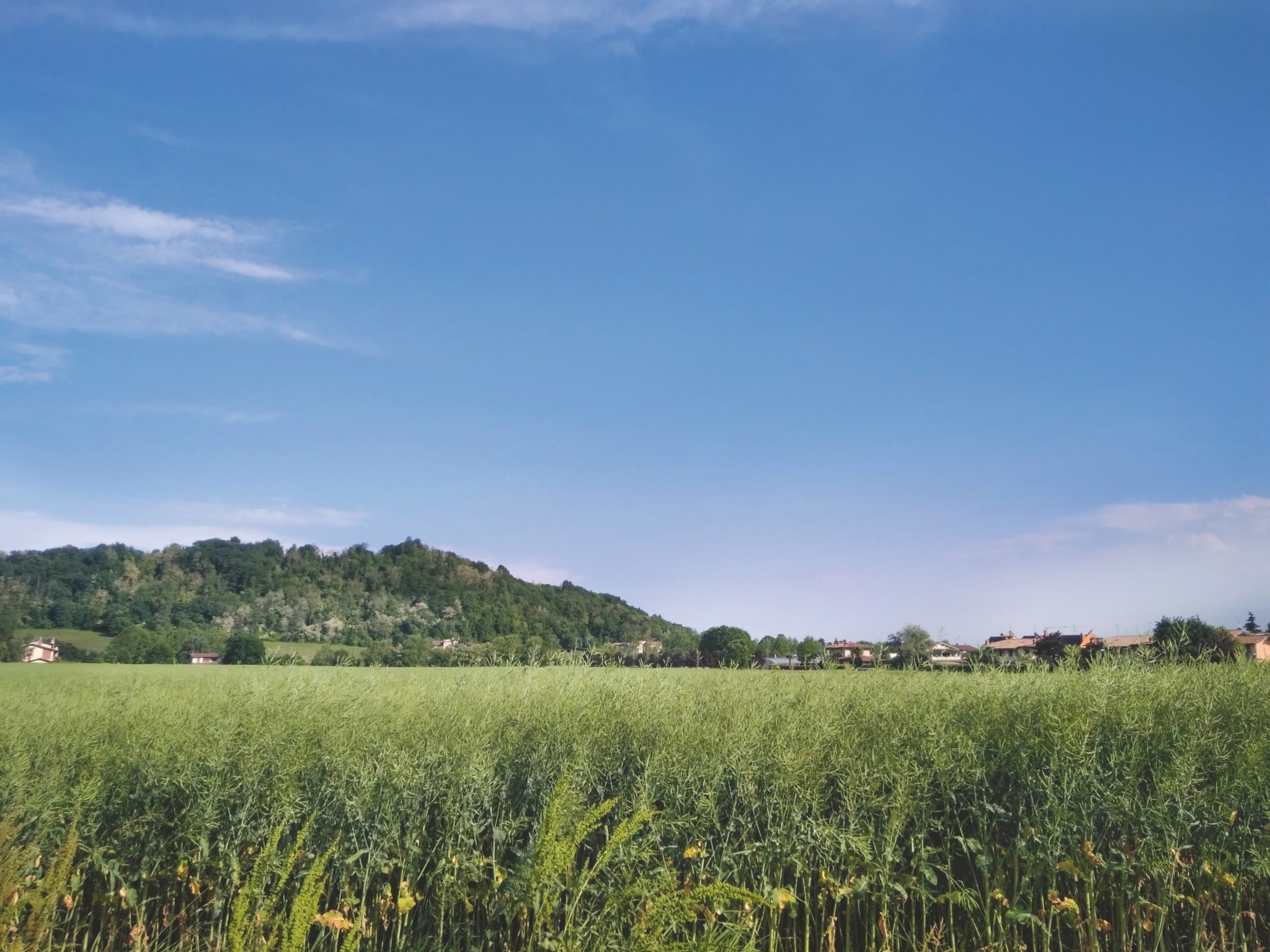
This is a double loop combined with a single itinerary. The first loop runs over the hills of the “PLIS delle Valli d’Argon” supra-municipal local park, which overlooks the plain. Not far away, the final hill relief emerges at Colle Tomenone. We therefore propose crossing the strip of plain, characterised by the warehouses and yards of numerous craft and industrial activities, to reach this wooded area that extends southwards, gradually fading into the plain between the municipalities of Brusaporto, Bagnatica, Costa di Mezzate, and Montello.
This second loop is well worth exploring because of the strong contrasts between the industrial areas to the north and the variety of environments and landscapes to the south. The proposed paths are beautiful and well maintained; however, it is strongly advised not to walk them after a rainy period, to avoid the risk of slipping like on a bar of soap.
ITINERARY DESCRIPTION
Below you will find a brief description. To follow the proposed route faithfully and not get lost between forks and right or left turns, we recommend using the GPX track.
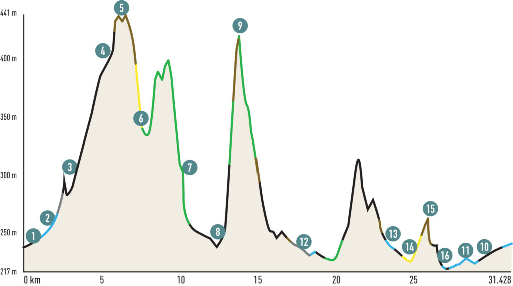
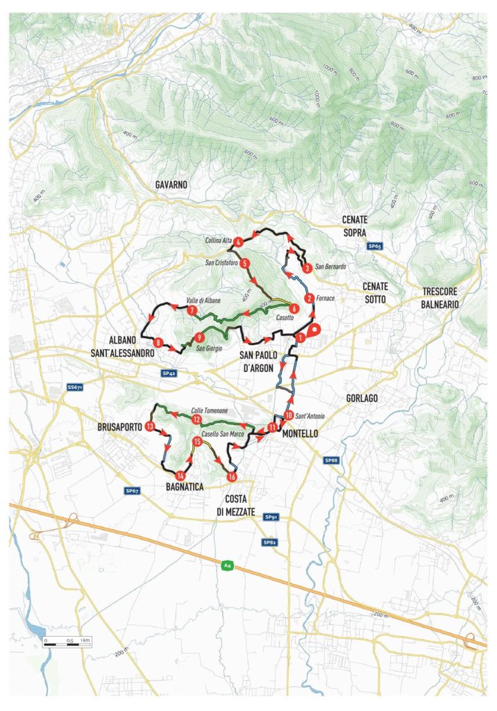
From the car park of the municipal sports centre of San Paolo d’Argon (1), follow via Colleoni. At the roundabout, turn right into via Benedettini, which runs alongside the Seniga stream. Follow it to the end and, on the left, continue along via Mazzini, still skirting the stream. You thus leave the built-up area and, having reached the Fornace (2) locality, take the cycle path that crosses the Seniga stream several times, following the valley to its end, in a decidedly evocative environmental context.
After a last small bridge, face a paved ramp that leads to a small church. Turn right and, along via Filistei, you will reach the church at San Bernardo (3). Turn left here and climb up to the hill along via Collina Alta (4). From the vineyards and hills of Scanzo, turn left towards Torre de’ Roveri. After a short stretch, turn left at a small rise. After passing an asphalted stretch, at a fork in the road, do not proceed towards Tenuta Frizzoni, but climb to the left along a short concrete ramp, at the end of which a dirt road begins that runs along the ridge between woods and meadows, offering splendid views of the plain, Mount Misma, and the Colli di San Fermo. The track culminates at the little church of San Cristoforo (5) and continues with a downhill stretch, interrupted by a few short counter slopes. You come to a fork in the road: ignore the climb towards the little church of Madonna d’Argon and descend to the left along a dirt track that turns into a mule track, leading to the hamlet of Casotto (6). Here, turn right and, instead of following the cemented road downhill, take a path that cuts across the hillside, overlooking the village of San Paolo and the plain. The so-called Sentiero della Luna (Moon Path) is smooth and fun. At a certain point it joins another path: follow it to the right, tackling a short pushing section. Then return to the saddle and, after passing two short ramps, pedal until you return to the ridge of Mount di Albano. Here, turn left and, at a bench, take a path to the right that descends on the northern slope of the mountain, ending in Valle d’Albano (7).
Return to asphalt and walk along the perimeter of the hill, passing through the village of Albano Sant’Alessandro (8). Having reached via San Giorgio, ride along it to the end, where a short, steep paved ramp leads to the beginning of the path to the little church of the same name. Push your bike up the first flight of steps and along the steep dirt track to the panoramic hill dominated by the small church of San Giorgio (9). Behind the church begins a path that descends along the ridge: at the first fork, turn right towards the southern slope. The smooth and pleasant path ends on a dirt track leading to the edge of the village of San Paolo d’Argon (1). Return to the starting point and head south in the direction of Montello.
Cross via Nazionale, near the bridge over the Seniga stream, and take the cycle/pedestrian path along its banks. Follow it to the end, where you cross the watercourse and take the dirt road under the highway to via San Lorenzo. From here, turn right onto the cycle track leading to Montello. At the small church of Sant’Antonio (10), cross the provincial road and continue towards Montello (11). Cross the Terra stream over the historic bridge and enter the village along via Colleoni. Keep to the right until you cross via Locatelli, which you follow as you ascend to the edge of the village, overlooking the northern slope of Mount Tomenone.
Now walk along the entire northern slope of Mount Tomenone. In the first part, the path is smooth and rideable, although it initially overlooks the Montello industrial plant. Near the summit of Tomenone, return to the hill from where the path branches off to the south. From here, continue on the northern slope, descending a steep flight of steps to a spring. The second part is wilder and includes short sections where you have to get off your bike. After completing the traverse, you come out onto via Cantalupa, which you follow to the left. At a bend, take a dirt road (via Delle Querce), which descends to via delle Robinie. Follow it to the left and cross the agricultural and forest area north of Brusaporto (13).
Continue along via degli Aceri, a road closed to traffic and reserved for pedestrians and bicycles. At the end, turn right into via Beder and then left into via Belvedere, which leads to Bagnatica (14). Continue between the houses along via Leopardi, via Roma, and via Tomenone, which turns into a mule track and leads to Casello San Marco (15). Climb a short concrete ramp up to the hill and descend along the mule track that skirts the forest, arriving in the agricultural basin between Costa di Mezzate and Montello. The mule track becomes a dirt road that takes you directly to the historic centre of Costa di Mezzate (16).
From here, following via Foppa and via Cornelle, return to Montello and retrace via Colleoni, returning to the starting point. Finally, head towards San Paolo d’Argon along the via San Lorenzo cycle path.
Scan the QR code to get information about the parking

