
SPINONE AL LAGO – RANZANICO – PRATI DEL SOLE – BIANZANO
A beautiful loop trail (not to be missed!) climbs to the classic Forcella di Ranzanico, with an optional extension to Prati del Sole. The route then descends exclusively on paths and mule tracks leading back to the lakeshore. For the first part of the ascent, we suggest an enjoyable alternative route to the nearby provincial road up to Ranzanico. The second part follows an asphalt road with zero traffic, as it is closed and restricted to transit.
The descent can be divided into three distinct sections. The first, offering panoramic views, crosses the Prati del Sole and descends to Forcella di Ranzanico. The second section is wilder, with a path featuring some challenging sections that lead to Bianzano. The third section follows a picturesque paved mule track, charmingly named “Via degli Asini” (Donkey Road), which winds down to the center of Spinone.
ITINERARY DESCRIPTION
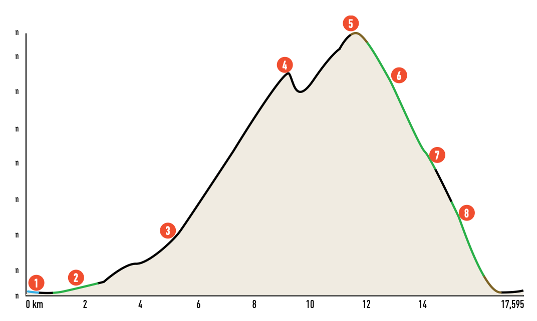
At the Castle of Monasterolo (1), a fortification situated where Lake Endine gives rise to the River Cherio, near the endpoint of the Val Cavallina cycle path, your route begins. From SP 76, at the edge of the built-up area, take via dei Carpini until you reach the watercourse. Here, turn right to head upstream. Pass the barrier and continue along the dirt track until you reach a small bridge over the Cherio. Cross it, and instead of following the stream, climb up towards Spinone al Lago (2). Take care when crossing the main road at the bottom of the valley.
Now, ascend via I° Maggio and turn right onto via XXV Aprile. Shortly after, turn left and follow the pedestrian walkway along a ditch until you reach Via alla Fonte, where you turn right. Pass by the Fonti San Carlo di Spinone. With short detours along via del Tuf, you can climb to the Sorgente Spinosa. Alternatively, proceed towards the village center, cross it, and continue along via Armando Diaz until you turn left onto via Spineda, which eventually becomes a path.
Follow the path that runs halfway up the hill for over 1.5 km. The track is easy to ride for the most part, with only a few short, steep stretches. Stay on the main track until you reach the provincial road that ascends to Ranzanico (3). Follow it to the village center, and from the small square behind the town hall, turn right onto via Silvio Pellico. Follow this street until you take the steep via Diaz branching off to the left. This road connects to a hairpin bend on the regulated traffic road, which you will follow to the Forcella di Ranzanico (4).
The asphalt ascent includes steep but manageable sections and offers surprising panoramic views of the lake and Val Cavallina, with the Colli di San Fermo massif rising on the opposite side. Upon reaching the Forcella, cross the descent path. If preferred, you can skip the ascent to the Prati del Sole, but this additional segment is highly recommended for its scenic beauty.
From the Forcella, descend along the tarmac road towards Peia. At an altitude of 890 m, join the road climbing from Peia. Turn right and ascend to Prati del Sole (5). After a steep ramp on a concrete surface, the road becomes a dirt track and continues towards Monticelli, where you will intersect with CAI trail marker 513, signaling the start of the descent. Turn right and follow the CAI sign to descend towards the Forcella di Ranzanico. The dirt road crosses meadows and pastures, passing near farmsteads. Follow the signpost, leave the road, and take a path on the left leading back to the Forcella.
From here, descend a few meters to the left along the tarmac road, then immediately take the path to Ranzanico (CAI signpost 618) on your right. Descend a short distance and veer right, following signs for the Sorgente di Bondo (6). The path runs diagonally and is generally easy to navigate. Upon reaching the spring, cross the small valley and continue downhill. The initial section is steep. Avoid left detours and stay on the path, which becomes progressively narrower, wilder, and more beautiful.
A steep section with narrow hairpin bends and technical passages follows, transitioning into gravel and loose surfaces. The long diagonal ends on a cemented road at Piazza del Vento (7). From here, ride through the charming village of Bianzano (8), passing near the Parish Church of San Rocco and Suardi Castle. At the foot of the castle, cross the provincial road and follow CAI signpost 605 to take the paved mule track, “Via degli Asini”, the historic road linking Bianzano and Spinone. Initially wide and carriageable, the mule track narrows, descending through woods and meadows with a well-maintained surface.
The descent ends in the center of Spinone al Lago (9). Cross the village on your way to the lakeshore via via Diaz, via Verdi, and via dei Panni. At the lakeside, turn right and follow the footpath leading to the small bridge over the Cherio and the Castle of Monasterolo, returning to your starting point.
Scan the QR code to get information about the parking

Credits: bibliography “MTB from Bergamo to the Endine and Iseo Lakes” Versante Sud Editions


