ENDINE – MONTICELLI – MOUNT GRIONE – SOVERE
A grand loop route with breathtaking views stretching over Val Cavallina and Lake Endine, all the way to Lake Iseo, and across the Bossico plateau, reaching Val Borlezza and the Presolana massif. This route does not present any significant technical difficulties, although, along the ridge line, there are short sections where pushing is necessary due to counter-slopes.
The itinerary can be divided into four sections. The first is a long asphalt climb from Endine to Prati del Sole, following secondary roads with little to no traffic. The second section is a diagonal stretch along a dirt road from Prati del Sole to Monte Grione, scenic and panoramic, punctuated by short but steep cemented ramps. The third section features an endless, wild ridge trail that descends towards Possimo and Sovere, with no particular technical challenges, apart from a few counter-slopes requiring some pushing. The final section is a mid-slope return with continuous ups and downs, following dirt roads, mule tracks, trails, and traffic-free paved roads.
ITINERARY DESCRIPTION
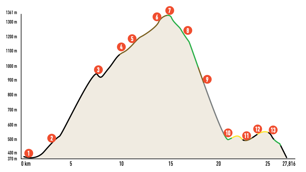
From the car park at the Endine cemetery (1), head towards the center of the village. After crossing the main road at the bottom of the valley, ascend via Martiri della Libertà. Continue along via della Repubblica, where panoramic views of the lake and valley begin to emerge. Turn right onto via Panoramica and follow it toward Ranzanico (2). Just past the San Bernardino Church, another scenic viewpoint, turn right onto via Luigi Cadorna.
The initial stretch of via Luigi Cadorna is steep, but it soon transitions to gentler gradients with long diagonals that wind through the woods descending from Monticelli and Sparavera toward the lake. Pedal steadily to reach the Forcella di Ranzanico, a closed, traffic-free road. The climb is steep in sections but rewards you with spectacular views of Lake Endine, Val Cavallina, and the Colli di San Fermo massif on the opposite side.
At the Forcella, descend on the asphalt road toward Peia. At an altitude of 890 m, you will rejoin the road climbing from Peia; turn right and ascend to Prati del Sole (3). After a steep concrete ramp, the road turns into a dirt track leading to Monticelli – Malga Longa. Follow the track, noting that the steepest sections are paved with concrete. Always follow the signs for Malga Lunga.
At Monticelli (4), expansive views open up toward the lakes and the Pizzo Formico and Orobic peaks. Continue past a paved ramp onto a long mule track traversing the southern slopes of Mount Sparavera. At the junction for Botta Alta, leave the flat track and ascend left, still following signs for Malga Lunga. This steep dirt track leads to Alpe Comunaglia farmstead (5). Here, concrete pavement eases the ascent to the ridge, marked by a scenic puddle overlooking the meadows.
Follow the dirt track to the right, navigating some ups and downs as you move onto the northern slope of Mount Grione among fir woods and clearings. At the end of a flat stretch, take a steep dirt road branching to the right, climbing through the woods to two dwellings near the summit of Mount Grione (6).
Pass the second house, circle around it, and cross the square at its rear. Continue past the fence on the opposite side, taking the CAI 628 trail, which follows the ridge. The ridge offers a long, rewarding trail, punctuated by short, steep counter-slopes that may require pushing. The trail is not always well-marked but remains technically manageable. It leads to the Croce di Grione (7).
From Croce di Grione, avoid descending directly to Palate. Instead, follow the watershed toward Possimo (CAI trail sign 563A). Upon reaching the Possimo huts (8), you will find a panoramic spot overlooking the lakes and the Presolana massif. Follow the road and take the main path descending to Sovere.
As you descend the long cement road into Sovere (9), turn right at the second hairpin bend (the first to the left). This path cuts through the wooded slope and descends toward a meadow. Avoid descending to the houses; instead, turn right and follow the trail slightly uphill into the forest. After crossing a small valley near a farmstead, descend along a dirt road.
At the end of the dirt road, turn right and climb a wide mule track. Upon reaching the houses on via Valle delle Fontane (10), continue along a dirt road at mid-slope rather than descending. When the dirt road meets an asphalt road, turn right and climb to the hamlet of Palate (11).
From Palate, continue on a dirt road following CAI signs to Fanovo (12). After passing the small church in Fanovo, descend along an asphalt road, returning to Endine (1) and your starting point.
Credits: bibliography “MTB from Bergamo to the Endine and Iseo Lakes” Versante Sud Editions