ENDINE – SAN DEFENDENTE – MOUNT CLEMO – RIVA DI SOLTO
Up and Down Mount Clemo: Between Val Cavallina and Lake Iseo
This route combines scenic asphalt climbs and rideable mule tracks with engaging descents on single trails, offering a dynamic and rewarding cycling experience. The landscapes are unparalleled, featuring breathtaking views of Lake Iseo. At the end of the final descent, you can enrich your outing by visiting the Valle del Freddo Nature Reserve, a guided tour that adds a unique dimension to the day.
The trails on this route are characterised by particularly well-draining terrain, making them suitable even after periods of rain. Additionally, several variations can be explored, especially on the northern side towards Lovere and Castro, offering opportunities to adapt the route to your preferences. This itinerary invites repeated exploration, allowing you to fully appreciate the beauty of the two lakes and their surrounding natural environments.
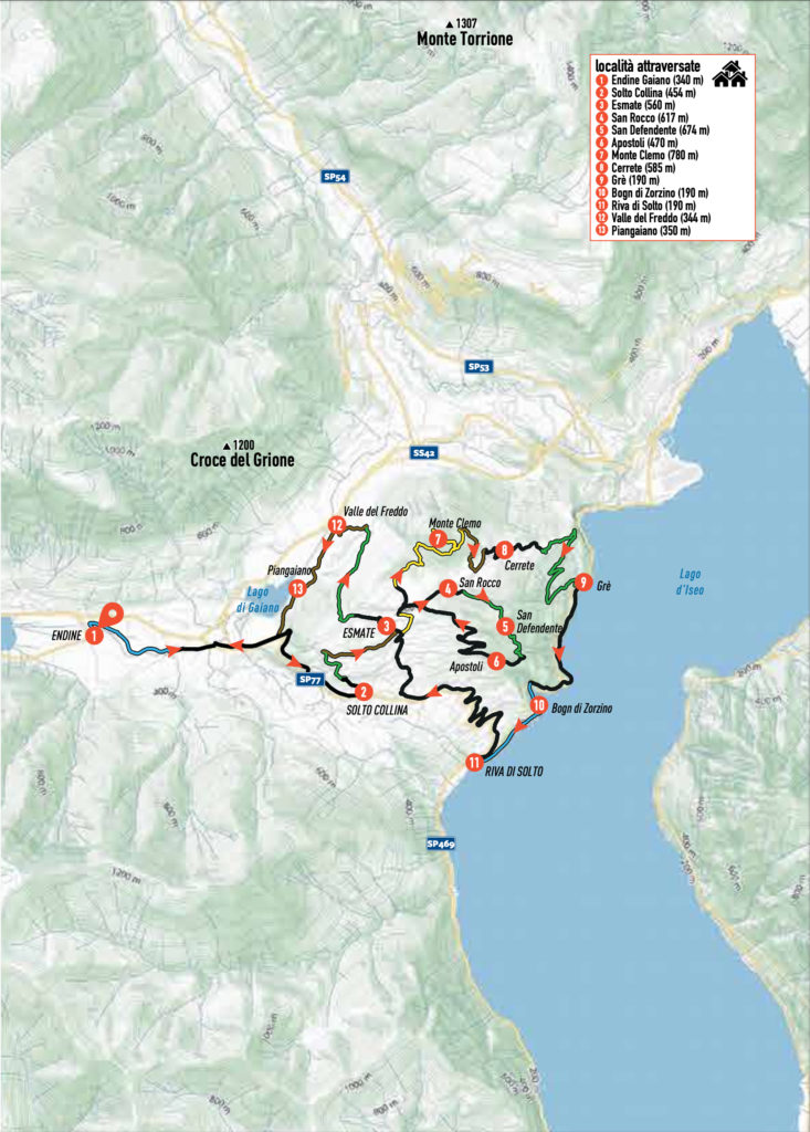
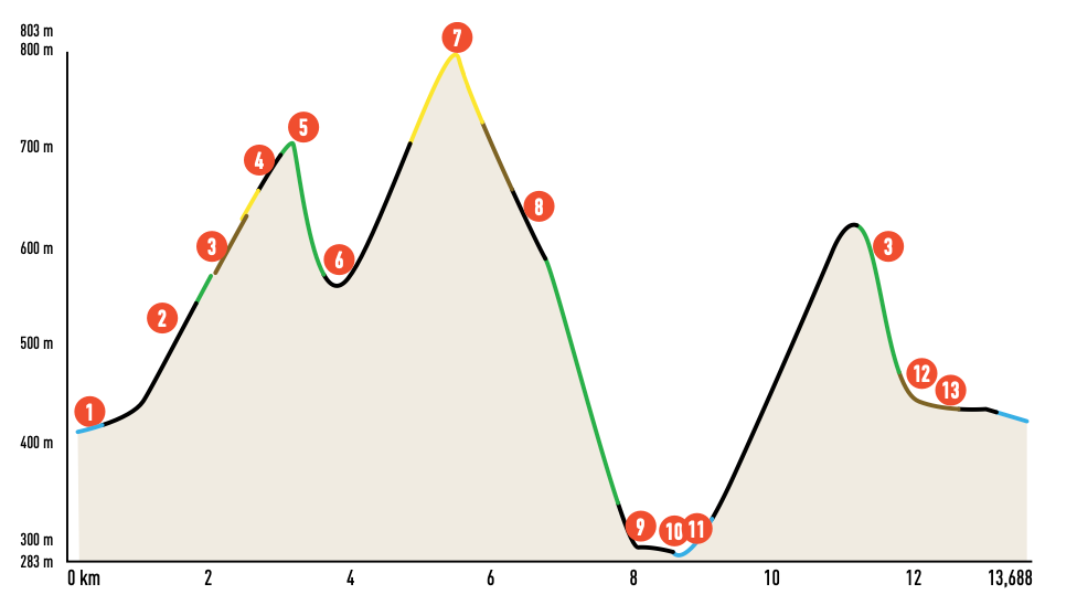
ITINERARY DESCRIPTION
Begin by walking along the perimeter wall of the Endine cemetery (1), located to the left of the entrance, and follow the small road that runs alongside the Fossadone stream. The road soon transitions to an unpaved path. After fording a small, typically dry valley, continue upstream, crossing a public green area characterized by a small lake and a Civil Defence dog training area.
Follow the towpath until you reach via G. Paglia, where you turn right briefly before turning left onto Via Campone. When you reach the main road (via Gaiano), turn right and follow it to Solto Collina (2).
Once in the village, take the first roundabout to the left and ascend via Broletti. After the first hairpin bend, turn left and follow the “Sentiero Natura del Sebino” (Sebino Nature Trail) signs. This leads to a small road that quickly becomes a mule track entering the woods. Follow the trail, which alternates between gentle ups and downs, until you reach a dirt track. Turn right and climb the track, passing meadows and cultivated fields. At a fork, turn left and ascend a mule track running alongside a private property.
Continue on the mule track until you intersect the tarmac road ascending to Esmate (3). Turn right briefly and then immediately left, following the “Sebino Nature Trail” signs. The dirt road, which initially runs flat along fenced properties, transitions into a mule track climbing to a sharp left turn. Do not continue straight but follow the mule track uphill, emerging onto a paved road near a house.
From here, take the via Monte Clemo and continue until you reach the small church of San Rocco (4). Turn right onto a dirt road, and after about 200 meters, take another mule track on the right. This track climbs in a series of bends to the Hermitage of San Defendente (5), a 16th-century structure offering extraordinary views of the entire Sebino area.
From the hermitage, descend approximately 200 meters in altitude back to Solto Collina. The initial section of this descent is a steep single track with rocky obstacles and steps requiring technical skill. After the challenging section, the trail smoothens out, eventually leading to a dirt track and then to the asphalt road via Apostoli (6). From here, start climbing again.
At the beginning of cia Papa Giovanni XXIII, turn right and ascend a dirt road. After a hairpin bend, rejoin a small paved road, following it to the right. Upon reaching via Mazzini, turn left. This pleasant climb, surrounded by greenery, passes farmland and wooded areas with lovely views of the lake.
At a crossroads, turn right and climb cia Clisano to rejoin via Mount Clemo, which you followed earlier. Turn left and descend slightly toward Esmate (3). Take the second small road on the right, marked “Sentiero Natura del Sebino.” After a few meters, the path becomes a dirt track and eventually a mule track, climbing through woods and meadows along the lower slopes of Mount Clemo (7). At a fork, proceed uphill to the left, shortly reaching the summit.
From here, a mule track leads to the wooded peak of Mount Clemo, which lacks panoramic views. Prepare for the second descent, heading back to the earlier crossroads. Turn left and continue on a dirt road bypassing Mount Clemo. At the first fork, turn right to descend through the forest along dirt tracks with some cemented sections.
Before completing the descent, on the plateau of via Cerrete, turn left and follow a path that climbs slightly to a tarmac road. Follow this road downhill to Cerrete (8). When you reach via Cerrete, turn left and descend further on via Tonale until it ends at via Picco Trenta Passi. For a stunning view of Lake Iseo, ascend the nearby hump.
Continuing left, a dirt road begins, leading to a spectacular path descending to the lake. Aside from a few technical sections, this path is smooth and scenic, featuring panoramic diagonals and tight hairpin bends. At a viewpoint over Lovere, Valle Camonica, and the Adamello glaciers, turn right (CAI signpost 565).
Follow the midslope trail, and at the first fork, descend left onto CAI path n° 566. This trail cuts across a steep slope down to the lake, culminating in a technical but beautiful section. Eventually, you reach the coastal road SP 469 in the locality of Grè (9), near a marble workshop.
Follow the coastal road southwards, soon arriving at the Bogn di Zorzino (10), dramatic cliffs overlooking the lake. Avoid the tunnel and instead climb over a small wall to follow an old road (closed to traffic) that passes beneath the cliffs, now equipped for climbing. A small beach nearby offers a refreshing swimming opportunity.
Continue along the small road, passing through a short tunnel and then along the lakeside promenade to Riva di Solto (11). This charming village is worth exploring and provides an excellent spot to rest before the final climb.
Behind the village, take the provincial road climbing to Solto Collina, passing through the hamlets of Gargarino and Zorzino. Upon reaching Solto Collina again (2), turn right onto via Santa Eurosia and then immediately onto via IV November. Continue climbing until turning left onto via Pietra Grossa, which becomes increasingly steep.
At the end of this road, turn right uphill, crossing via Adamello and continuing onto via delle Crappe. After climbing to its end, turn left and then right, ascending once more into the village of Esmate (3).
Before reaching the church, take via Santa Lucia (CAI signpost 565) and follow it to the Valle del Freddo. After leaving the village, continue along a dirt road. At the first fork, turn right and begin the descent. Leave the dirt road immediately to the left, taking a path descending into the Valle del Freddo biotope, a protected area rich in flora and fauna.
Continue downhill until you cross the provincial road, which you follow back to Endine (1), completing your hike.
Credits: bibliography “MTB from Bergamo to the Endine and Iseo Lakes” Versante Sud Editions