ENDINE – FONTENO – MOUNT SICOLO
A loop tour with no hesitation or half-measures: there are only two options — climb or descend. After a demanding and relentless ascent along the Torès mule track and the Brugai path (a mix of dirt roads and paved sections), you can catch a breather between the two forks — Nigoli and Mount Sicolo — by following a stunning single-track. This trail is almost entirely rideable and offers breathtaking views of both Lake Endine and Sebino.
The descent is a long and spectacular trail that leads you directly back to the starting point, bringing this captivating route to a beautiful conclusion.
ITINERARY DESCRIPTION
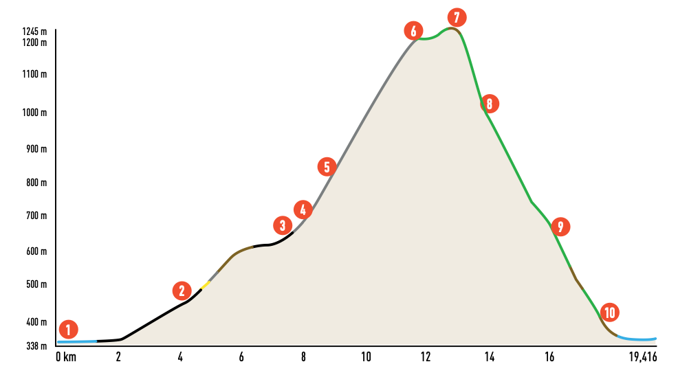
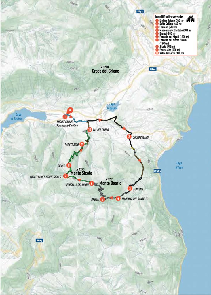
Starting at the Endine cemetery (1), walk along the perimeter wall to the left of the entrance and take the small road following the towpath of the Fossadone stream, which soon becomes a dirt road. After crossing a small (generally dry) valley, head upstream along the watercourse, passing through a green area that features the Voluntary Civil Defence Dog Training Area and a small lake.
Continue along the towpath until you reach via G. Paglia, where you turn left and then right onto Via Campone. At the provincial road (via Gaiano), turn right and cycle towards Solto Collina (2).
In the village, turn right again and follow the signs for Fonteno. The asphalt road begins to climb, and after about 700 metres, you will reach a shrine at the junction with via Sales. A little further on, take the steep road branching off to the right, then immediately turn left, following the CAI 567 sign.
Descend briefly along a path to a spring, cross a small valley, and continue on a picturesque trench path that eventually joins a dirt road. Follow this road (marked CAI trail 567), navigating several hairpin bends, some with concrete paving. The path continues on a long diagonal that circumnavigates Colle di Luen and leads to the centre of Fonteno (3).
The views of Lake Iseo and the Fonteno Valley are stunning. The village, surrounded by lush greenery, is perched halfway up the mountainside in a splendid position. Pass through the village centre, and from the piazza, ascend via Campello to the small Church of Divo Rocho, then continue to the right.
The narrow asphalt road marks the beginning of a steeper climb, leading out of the village to the Mulattiera del Torès, a paved mule track. Ascend steadily to the Madonna del Santello (4), where a stop is highly recommended.
The mule track continues under the portico of the small church and proceeds uphill. Fortunately, some less steep sections allow for brief rest stops. At the first fork, turn right and follow signs for the Sentiero dei Brugai (5), a dirt road with steep concrete-paved sections that ascends the slopes of Monte Boér through the Brugai forest, winding through 15 hairpin bends.
At the end of this section, you will find a shrine and a water fountain. A short distance beyond, turn right to reach the Nigoli Pass (6), where you join the ridge path connecting Mount Boér to Mount Sicolo and Mount Torrezzo. Turn left towards the latter.
The trail at this elevation is almost entirely rideable, with only two short sections requiring you to push your bike. On the right side of a gated road, the path marked CAI 568 continues with short undulating sections. Shortly afterward, you return to the ridge, crossing a clearing with a hut (exercise caution during hunting seasons).
As you traverse the southern slopes of Mount Sicolo (7), you will reach La Fopa del Còl, where informative panels describe the Bueno Fonteno – Nueva Vida karst system, a renowned site for speleologists. From here, the trail descends to a dirt road; follow it to the right to reach Casini, near the Mount Sicolo saddle, where the main descent begins.
The descent, marked CAI 620, is spectacular and diverse. It begins with a steep technical section featuring rocky surfaces, narrow hairpin bends, and challenging passages that demand good technique.
At the Sicolo hut clearing (8), pause to admire the panoramic views of Valgandino and Bossico before descending to the roccolo. From this point, the trail becomes smoother and more flowing, alternating fast straightaways with tight hairpin bends, eventually leading to the wide meadows of Parete Alto (9).
Here, the trail transitions into a steep trench with technical sections that lead to a track along the edge of the meadow. Follow this track until it connects to the dirt road servicing the Parete Alto farmsteads. Continue descending along the CAI signs, ignoring other deviations.
Alternatively, you can take a short trail leading to a small bridge over the Valle del Ferro (10). At a hairpin bend, where a dirt road branches off, stay along the forest’s edge and follow a faint track that descends near a farmstead and a high-tension pylon.
From here, the trail continues through a pine forest, eventually reconnecting with the dirt road you left earlier. Once you reach the small bridge and ford of the Valle del Ferro, turn left and descend along a dirt track that runs beside the valley, which features crystal-clear pools of water. This dirt track ends at via Paglia, where you rejoin the towpath from the start, completing the loop and returning to your starting point.
Credits: bibliography “MTB from Bergamo to the Endine and Iseo Lakes” Versante Sud Editions